Parish walk - 1  


Winterborne Houghton - Milton Abbas, circular walk - 5 miles 

(Distances in miles are relative to the starting point)                               Page 2


6. Take the bridleway down a shallow valley and enter the Wood. Continue into the wood for 200 yds until the bridleway meets a forest track and then go straight ahead for 50 yds. You will see the Jubilee Trail entering from the left and immediately after this, a bridleway rising steeply to the right (815 028).

Turn right up this bridleway (muddy in winter) and skirt the right hand edge of the wood for a quarter of a mile, joining a forest road at a sharp bend (814 024).

7. Turn right and follow the road round to the left past a corrugated farm building on the left. In 300 yds reach a metalled road that continues to a junction with the main road (810 021).

Turn left and follow the road for 200 yds to a triangle of grass with a brown sign to Milton Abbey


  MiltonAbbasSign.JPG (75768 bytes)

Milton Abbey

sign

8. Turn right and descend steeply into Milton Abbas past the Old Village Hall

picnic area and the school on the right, reaching the Hambro Arms in

approx. 350 yds (808 019).

(There is a teashop 200 yds further down the street on the left. Also, 

Milton Abbey can be reached via a footpath approx. half a mile from

 the lower end of the village).

  HambroArms.JPG (43947 bytes)

Hambro Arms

9. From the Hambro Arms, retrace your steps past the school and picnic site to a Bridleway sign on the left opposite a short section of metal railing (809 020). Turn left and ascend steeply through the wood to a small cul de sac in approx. 200 yds. In a further 50 yds at the entrance to this cul-de-sac, turn left and in another 200 yds, turn right at the "Athelstan Cottages" sign. Continue across another road and along a tarmac path that bears right toward the Catherines Well Millennium Green.

Pass through the Millennium Green and across a metalled road to a bridleway. You will see a pedestrian gate about 20 yds along this path leading into a field behind the row of houses.

10. Go through the gate and bear left across the field.

Pass through a gap in the hedge and continue up the track with a hedge of tall trees on your left. This continues for approx. 3/8 mile in a northwesterly direction past a private garden on the left to a junction with a track.

Turn right and in 150 yds look for a small concrete water trough next to a small tree on the left. There is a bridleway sign buried in this tree pointing to the left!

Turn left and follow the blue bridleway signs past a dense section of woodland on the left.
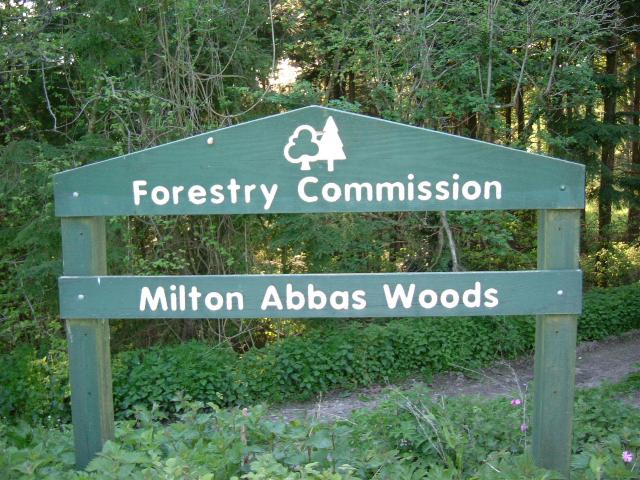
In approx. a quarter of a mile the bridleway joins a metalled road

(805 035). At this junction, there is a Forestry Commission sign to Milton Abbey Woods and a forest track on your left. 

 MiltonAbbasWoodsSign.JPG (77441 bytes)

Milton Abbas Woods 

Forestry Commission sign


 Next

 Home Page